Optical Mesosphere Thermosphere Imagers (OMTIs)
Institute for Space-Earth Environmental Research, Nagoya University
The Optical Mesosphere Thermosphere Imagers (OMTI) were developed at the Solar-Terrestrial Environment Laboratory (currently, Institute for Space-Earth Environmental Research), Nagoya University, in order to investigate the dynamics of the upper atmosphere through nocturnal airglow emissions.
In this homepage, plots of intensity, two-dimensional images, rotational temperatures, and Doppler wind velocities of nocturnal airglow obtained at several ground stations are available.
Digitial data in the CDF format and handling IDL softwares of all-sky imagers are available from the ERG Science Center. Metadata for these digital data are also available at IUGONET Type-A.
Please contact the Principal Investigators, K. Shiokawa before using these data for any publications and/or presentations.
Please note that the data in these plots are just for browsing purpose and are not fully calibrated.
- Important Notes
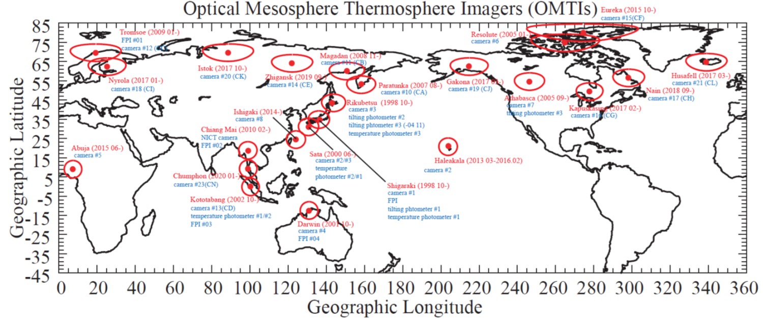
- Station Locations, Observed Airglow Lines, and Time Resolutions
- Figure Captions
- Instrumental Papers
- Publication List
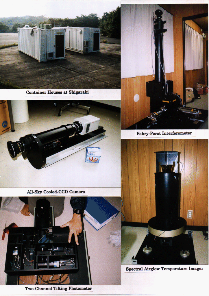
- Picture of the Instruments
- Sky Condition (1-hour value)
- Sky Condition (1-hour value, Canadian stations)
- Sky Condition (1-hour value, Ithaca (USA) station)
- Related Publications
Contact Address
Professor Kazuo Shiokawa and Dr. Yuichi Otsuka
Institute for Space-Earth Environmental Research, Nagoya University
Furo-cho, Chikusa-ku, Nagoya 464-8601, Japan
tel: +81-52-747-6419 fax: +81-52-747-6323
Links

This data has been registered in IUGONET (Inter-university Upper atmosphereGlobal Observation NETwork) metadata database.
The IUGONET metadata database will be of great help to researchers in efficiently finding and obtaining ground-based observation data spread over the institutes/universities.
Click and visit to the IUGONET website.
IUGONET also prepared the IUGONET Data Analysis Software (UDAS) for the upper atmospheric observation data.
If you install the UDAS, you can easily access, download, visualize and analyze the observation data through the Internet.
Please click and try to use the UDAS.
Acknowledgements
The OMTIs have been developed in collaboration with T. Kotoh, Y. Katoh, M. Satoh, and M. K. Ejiri of the Solar-Terrestrial Environment Laboratory, Nagoya University, T. Nakamura and T. Tsuda of the Radio Science Center for Space and Atmosphere (RASC), Kyoto University, and R. H. Wiens of the Center for Research in Earth and Space Science, York University.
We are grateful to Drs. M. Ishii, H. Fukunishi, H. Nakajima, S. Okano, Y. Takahashi, and M. Taguchi for their helpful comments and suggestions during the development of OMTIs. Mr. R. Maekawa is greatly acknowledged for his skillful help to construct the automatic control software for the cameras. The all-sky cameras and the photometers were calibrated using facilities at the National Institute of Polar Research, Japan. This Web browser for OMTI plots have been developed in cooperation with the Geospace Research Center of the STE Laboratory, Nagoya University.
The development and operation of OMTIs have been supported by JSPS Grants-in-Aid for Scientific Research (11440145, 13573006, 13136201, 16403007, 18403011, 19403010, 20244080, 23403009, and Priority Area 764), by JSPS Core-to-Core Program, B. Asia-Africa Science Platforms, by the Dynamics of the Sun-Earth-Life Interactive System (No.G-4, the 21st Century COE Program) of MEXT, Japan, and by the IUGONET Project.